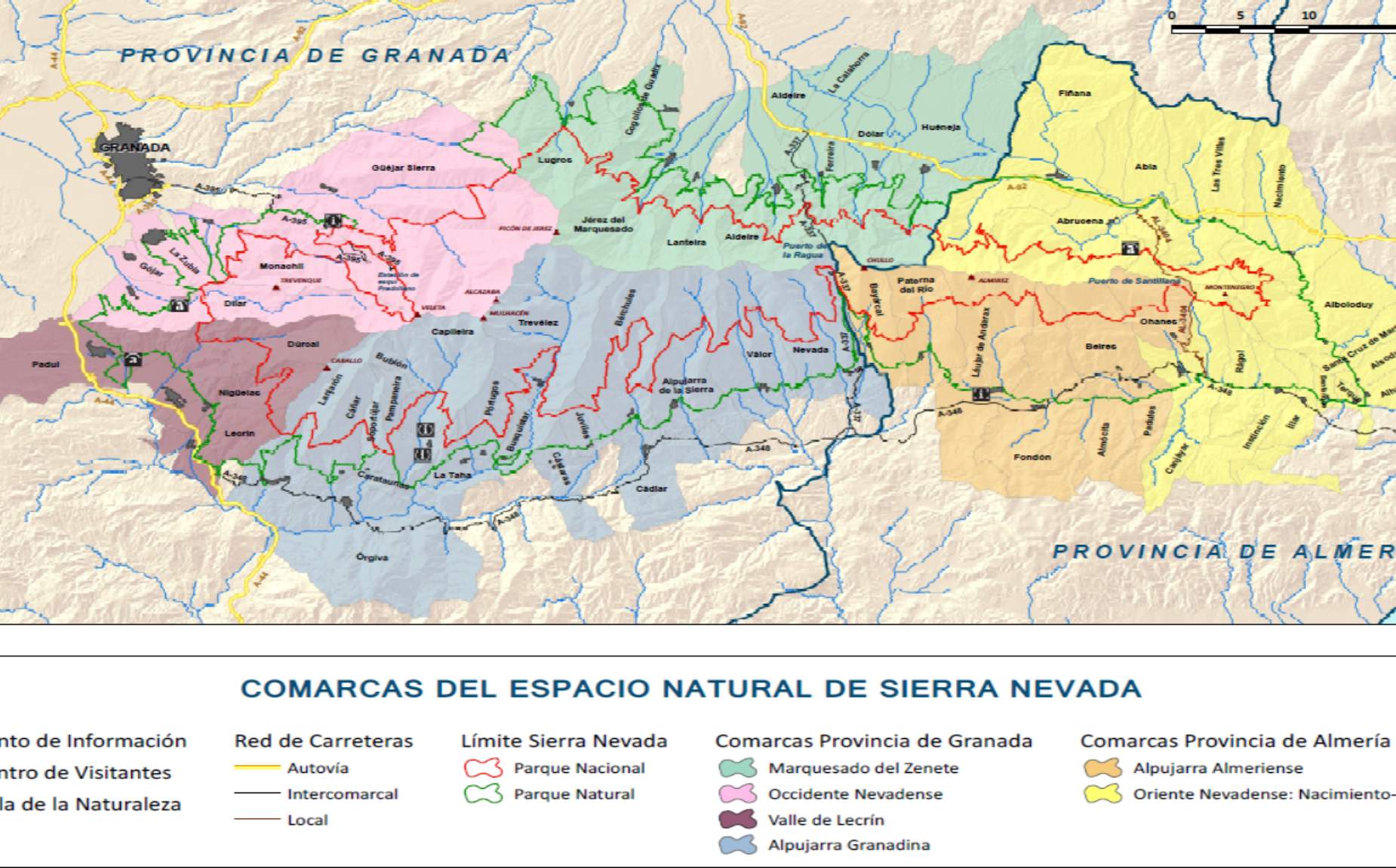
One mountain and 6 counties
Each region has its own culture, landscape, resources and traditions.
The Natural Park is spread over six different geographical areas
The Natural Park has such an extension, variety of heights, orientations, climate and soil that it is possible to distinguish up to six geographical spaces, where culture, landscape, resources and traditions are different:
Western Nevadan
The Sierra embraces Granada in the Nevadense West, a region at the foot of the mountain, where the middle mountain with mountain villages gives way to the valley and the capital of Granada in just 30 minutes. Paradoxically, the municipalities of these towns reach the apexes of the high peaks, so that their villages: Dílar, Gójar, Güéjar Sierra, Monachil and La Zubia, are a place to stay and a starting point for multiple activities, both towards the low and high mountains.
Lecrin Valley
Turning south counterclockwise we find the region of Valle de Lecrín, an area where the winter is mild and you can breathe the essence of the Mediterranean world: centenary olive trees, almond and citrus trees. You can centralize a stay in this region (Padul, Dúrcal, Nigüélas, Lecrín) and easily access the Alpujarra, Granada, the coast or the high mountains.
The Alpujarra
The Alpujarra is the best known region of the Sierra Nevada from the point of view of traditional tourism. It occupies the southern slopes of the mountain range, from Lanjarón to Alboloduy in Almería. Its many villages are located in sunny positions where the climate favors life. The mountainous and isolated character, the intact aspect of its villages rooted in the hillsides, turned the Alpujarra into an icon of the remote landscape, picturesque and essential territory for the romantic traveler. And this is how the region survives to this day, with an urban planning, architecture, network of medieval trails and water management systems unique in the world. It is undoubtedly the starting point for ascents to summits such as Mulhacén and Alcazaba and a paradise for the ecotourist who wants to stay, relax, ethnographic research, gastronomy and activities for all profiles.
Alpujarra of Granada and Almeria
Human geography subdivides this large southern area into two sub regions, the Alpujarra Granadina and Almeria. The Granada part begins in the municipality of Lanjaron and ends in Nevada, the easternmost municipality near the main mountain pass that divides the provinces, the Puerto de la Ragua. Much has been written about it and it receives most of the visitors. However, the eastern Alpujarra and Almeria is less known, perhaps because of its greater distance from the capital of Granada. Some characteristics give it its own entity: it is more rocky, has a greater coastal influence and is the connection with the desert. A more isolated area and, therefore, more unknown and authentic, although with the elements of the Alpujarra in terms of water management, terraced farming, architecture and urban planning of Berber origin.
the Río Nacimiento region
In our turn around the mountain range we begin to look to the north in the province of Almeria with the region of the Nacimiento River. The valley of this river connects the sloping hillsides of the sierra with the desert plateaus that continue to the east. The territory is still marked by contrasts in its landscape: high peaks with altitudes reaching 2500 m and with a great variety of plant formations and lower areas of softer and clayey reliefs generating surprising canyons or red-walled wadis.
Marquisate of Zenete
Closing our circular by the north face of Sierra Nevada we find the region of Marquesado del Zenete, where the forest touches the desert. This connection occurs, moreover, in a sudden way, as if the slopes that descend from the sierra were sectioned at 1,000 meters altitude by a horizontal plane. This unique connection between the mountain and the flat steppe or the mountain and the semi-desert furrowed by erosion, is what gives uniqueness to the Marquesado del Zenete and Zalabí Valley. Your stay in this region also allows you to explore the recently declared Geopark of Granada.


